Tornado Activity Ramps Up In May
Sign up for the Morning Brief email newsletter to get weekday updates from Weather Now 24 and our meteorologists.
Spring has already been packed full of damaging tornadoes,but May is typically the nation's most active month,although as recent years have shown that's not always the case.
The greatest tornado threat shifts and expands in May. Tornadoes are a possibility across a broad portion of the nation this month,from the Plains to the East Coast. But,the greater risk of tornadic storms is in portions of the Plains and Midwest. That's a change from earlier in spring,when the greatest risk of tornadoes is usually in the Deep South.

May's average number of tornadoes is the highest of any month. In the 20 years ending in 2022,May averaged 278 tornadoes annually. That's higher than April and June,which,on average,are the second (203) and third (188) busiest months for twisters,respectively.

The actual outcome in May can vary greatly. We've seen this in recent years,with as many as 510 tornadoes in 2019 compared to 126 in 2020.
Last year,March (206) had more tornadoes than May (169),illustrating the variability that can occur because of changeable weather patterns in spring.
The record most twisters in May is 542 in 2003.
It's not just the number of tornadoes,but also the intensity of them that makes May a dangerous month. May,along with April,is in the heart of spring when violent tornadoes (EF4 to EF5 damage) are more likely than any time of year.
That's important because even though all tornadoes pose a threat,about 46% of the deaths from 2019 through 2023 were from tornadoes rated EF4 (not just in May),according to data from NOAA's Storm Prediction Center.
Nine of the 25 deadliest U.S. tornadoes in history have occurred in May,based on estimates from NOAA's Storm Prediction Center. That's the most of any month,with April and June just behind with seven each.

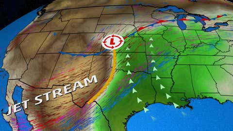
Why May is so ripe to spawn tornadoes. May is when Gulf of Mexico moisture is drawn farther northward most successfully by strong low-pressure systems when compared to earlier in spring. At the same time,a larger area of the country can heat into the 70s,80s and 90s for greater vertical cloud development
The jet stream is also still strong enough and located over the country’s midsection to cause strong wind shear over the Plains. Once we head into summer,the jet stream weakens and shifts toward the Canadian border,which takes away this ingredient.
Chris Dolce has been a senior meteorologist with www.weathernow24.com for over 10 years after beginning his career with Weather Now 24 in the early 2000s.