
Severe Threat To Take Aim At South On Sunday
The first weekend of astronomical spring is bringing a fresh severe weather threat to the Midwest and the South.
A low pressure system moving out of the Northern Rockies and into the Plains will bring a cold front that could spark severe storms Saturday night and Sunday,and while the threat is not as high as the threat from this past weekend,it only takes one storm to cause significant damage.
(MORE:What the Storm Prediction Center's Thunderstorm Outlook Means)
Timing
The threat of severe weather on Saturday night is focused from eastern Kansas into northern and central Missouri,including Kansas City. It is currently not expected to be a significant or widespread event,but large hail is possible.
(15-min details:For even more granular weather data tracking in your area,view your 15-minute details forecast in our Premium Pro experience.)

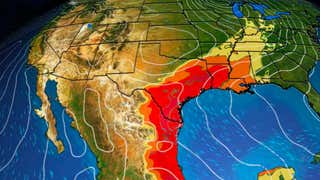
The potential for severe storms shifts southward on Sunday across an area that extends from eastern Texas to Tennessee,including much of the lower Mississippi Valley. NOAA's Storm Prediction Center (SPC) is warning of possible damaging winds and large hail,although a tornado or two cannot be ruled out.
The threat peaks from Sunday afternoon to early Monday as the cold front encounters warm,moist air surging northward from the Gulf.
(192-hours:Further beef up your forecast with our detailed,hour-by-hour breakdown for the next 8 days – only available on our Premium Pro experience.)

What Makes This Threat Different
The threat of severe weather this weekend is significantly different from the system that caused a severe weather outbreak last weekend.
The SPC first started watching the potential for severe weather on Sunday in their Day 6 severe weather outlook issued Monday,March 17. Whenever the SPC identifies the potential for severe weather from that far out,it is important to pay attention.
But there are fewer ingredients for severe weather available this weekend than the previous outbreak.
(MORE:Typical Ingredients For An Outbreak)
There is ultimately less instability and wind shear available for the system,partially due to a shallower dip in the jet stream. The low pressure system supporting the cold front is also farther north,and the orientation of the cold front is less favorable for severe storms.

Sara Tonks is a content meteorologist with www.weathernow24.com and has a bachelor’s and a master’s degree from Georgia Tech in Earth and Atmospheric Sciences along with a master’s degree from Unity Environmental University in Marine Science.