Tropical Storm Arlene is only the latest example of some rather strange happenings with tropical storms and hurricanes in the Atlantic Basin over the past five years.
(MORE:Hurricane Central)
Not only was Arlene a rare April tropical storm,but it formed farther north earlier in the calendar year than any other Atlantic tropical storm of record.
(MORE:What Happened the Last Time an April Tropical Storm Formed)
Here are several other weird things we've noticed going back to the 2012 Atlantic hurricane season.
2016
Thanksgiving Hurricane in Central America
- Hurricane Otto was the latest hurricane landfall on record in the Atlantic Basin,occurring on Thanksgiving Day.
- Otto was the southernmost landfall on record in Central America and the only known hurricane to move over Costa Rica.

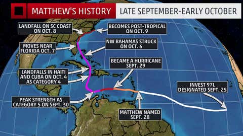
Infamous Matthew Peaks Near Colombia
- Matthew was the southernmost Category 5 hurricane on record in the Atlantic Basin,fewer than 100 miles north of the Colombian coast.
A May Landfall
- Bonnie soaked the Carolinas,making landfall along the South Carolina coast on Memorial Day Weekend 2016.
A January Hurricane,and a Landfall
Alex became just the second hurricane on record to form in the Atlantic Basin during the month of January. The last hurricane that formed in the Atlantic during January was in 1938,according to NOAA's historical hurricane tracker database.
Alex was also the first hurricane to occur in the Atlantic in January since Alice in 1955. Alice initially formed into a hurricane on Dec. 31,1954,but then remained a hurricane into early January 1955.
Alex became the strongest January hurricane on record (estimated 85 mph winds).
Alex made landfall on the island of Terceira in the central Azores with maximum estimated sustained winds of 65 mph.

2015
A Mother's Day Landfall
- Tropical Storm Ana was the second-earliest landfalling tropical storm on record in the Atlantic Basin.
- The following May's Bonnie landfall would be the second consecutive May with a Carolina landfall,each on a holiday weekend.

2014
Bermuda Back-to-Back
- Two hurricanes made landfall on the 20-square-mile archipelago within six days in mid-October.
- Bermuda had never been affected by two hurricanes so close together in time,let alone had both of them make landfall.

2013
Slumbering Season
- The first time since 1982 only two hurricanes formed all season.
- The first hurricane didn't form until Sept. 11 (Humberto),just three hours short of the longest wait on record for the first hurricane of the season,which was set in 2002.
- Neither hurricane reached Category 2 strength,the first time no single hurricane had reached that intensity over an entire season since 1968.

2012
Sandy's Track,Massive Size and Snow
- Sandy's diameter of tropical-storm-force winds was up to 1,000 miles before landfall,the largest tropical cyclone by wind field on record dating to 1988,according to the NHC final report.
- Sandy then took a bizarre west-northwest turn toward the Northeast Seaboard,thanks to blocking high pressure aloft over the North Atlantic Ocean.
- Sandy was so massive it produced damaging winds and waves in parts of the Great Lakes,and with some cold air,wrung out up to 3 feet of snow in the Appalachians,with blizzard conditions.

A Three-Week Scribbling Odyssey
- Nadine persisted as a tropical or subtropical cyclone for just over 21 days from mid-September through early October,the fifth-longest-lived Atlantic named storm at the time.
- Given its meandering,haphazard path,Nadine affected the Azores twice,producing gusts to 50 mph in localized areas each time.

Season's First Hurricane,in June,Really Far North
- Hurricane Chris became the 2012 season's first hurricane at 41 degrees north latitude – farther north than New York City – on June 21.
- Only a single 1893 hurricane was farther north as a hurricane in June than Chris.

Two Preseason Storms,One Almost a Hurricane
- Tropical storms Alberto,then Beryl formed before the "official"start of the 2012 Atlantic hurricane season,the first time that had happened since 1908 (1887 was the other year).
- Two preseason storms would happen again four years later in 2016 (see above).
- With maximum sustained winds of 70 mph,Beryl was the strongest tropical cyclone to make a pre-June 1 U.S. landfall on record.
(MORE:The 35 Strangest Weather Events I've Seen in My Lifetime)
Jonathan Erdman is a senior meteorologist at www.weathernow24.com and has been an incurable weather geek since a tornado narrowly missed his childhood home in Wisconsin at age 7. Follow him on Facebook and Twitter.
MORE ON WEATHER.COM:Atlantic Basin Retired Hurricanes and Tropical Storms