The record-long U.S. major hurricane drought has gotten plenty of publicity, including here on www.weathernow24.com.
(MORE: Hurricane Central)
Yes,a Category 3 or stronger hurricane hasn't made landfall in the U.S. since Hurricane Wilma in late October 2005,almost 11 years ago.
However,a recent study published in the May 2016 issue of the Bulletin of the American Meteorological Society (BAMS) pointed out that this "drought"is just an artifact of the data,not a real thing,per se.
The fact is,you don't need a Category 3+ hurricane to produce major impacts,including storm surge flooding,rainfall flooding and damaging winds,among others.
Here are 10 examples,in reverse chronological order, of U.S. tropical cyclones after Wilma that produced major,destructive impacts.
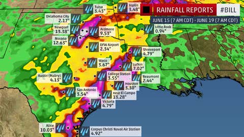
Tropical Storm Bill (June 2015)
Still recovering from a record wet May,parts of the southern Plains were swamped by this tropical storm just weeks later.
Over a foot of rain fell in parts of Texas and Oklahoma,triggering widespread flash flooding and pushing a few rivers to record flood levels in Texas,Oklahoma and Missouri.
(FULL RECAP: Bill Leaves Behind Flooding in the U.S.)
Hurricane Arthur (July 2014)
Arthur was the first hurricane to strike the U.S. in almost two years when it hammered areas from the Carolinas to southeast New England over Fourth of July 2014.
Wind gusts up to 101 mph and up to a 4.5 foot storm surge hammered parts of eastern North Carolina as the eyewall moved through. Up to 8 inches of rain soaked southeast New England,with wind gusts topping 60 mph on Nantucket Island.
Arthur also made landfall earlier in the calendar than any previous North Carolina hurricane of record.
(FULL RECAP:Arthur Disrupts Fourth of July Weekend)
Superstorm Sandy (October 2012)
Whatever meteorologists called it -- it techincally was not a hurricane at landfall -- Sandy's siege on the East Coast was responsible for an estimated $71.4 billion on damage,second only to Hurricane Katrina on the costliest list of tropical cyclones.
A massive storm surge pushed water levels up to 9 feet above ground along the Jersey shore,Staten Island and Manhattan. Roughly 346,000 homes were damaged or destroyed in New Jersey alone,reported the New York Times.
There was even a crippling snowstorm,with up to 3 feet of snow,in the Appalachians on the backside of this superstorm.
(FULL RECAP: Superstorm Sandy Diary)

Hurricane Isaac (August 2012)
While only a Category 1 hurricane at landfall,Isaac's large wind field generated an extensive storm surge along the Gulf Coast from Louisiana to Florida.
Hardest hit was parts of Plaquemines Parish,Louisiana,where storm tides up to 17 feet above ground level spilled over a back levee,swamping the community of Braithwaite. Major surge flooding also swamped unprotected parts of seven other Louisiana parishes,inundating parts of the cities of Slidell and LaPlace.
Surge flooding up to 9 feet above ground was estimated in southern Mississippi,and was believed to have pushed north of Interstate 10,in some spots.
(FULL RECAP:Why Isaac Should've Been Retired)

Tropical Storm Debby (August 2012)
One example of the dangers of a system that never became a hurricane,Debby's dawdling in the Gulf of Mexico led to proflific rainfall and rather impressive storm surge flooding,relative to its intensity.
A swath of central and north Florida into far south Georgia picked up over 10 inches of rain,triggering the most severe flooding in Live Oak,Florida,since 1964. More than 20 miles of Interstate 10 were flooded and closed in north Florida.
Jacksonville set an all-time two-day rain record (13.78 inches),which flooded homes and prompted water rescues. Storm surge combined with rainfall triggered heavy flooding in Tampa-St. Petersburg.
(FULL RECAP:Tropical Storm Debby)

Tropical Storm Lee and Its Remnant (September 2011)
Lee produced a peak storm surge of just over 4.6 feet and locally over 10 inches of rain along the northern Gulf Coast,but it was more infamous for what its remnant did in the East.
Torrential rain,some falling on areas soaked by Irene just weeks ago,triggered flooding along the Susquehanna River topping previous records set during the remnants of Hurricane Agnes in 1972. Almost 21 inches of rain fell near Colonial Beach,Virginia,and over 10 inches of rain fell in Binghamton,New York.
Dr. Greg Forbes, severe weather expert for Weather Now 24, estimated that 29 trillion gallons of water were dumped over a swath from Louisiana and Mississippi to Pennsylvania and New York.
(FULL RECAP:Tropical Storm Lee)

Hurricane Irene (August 2011)
Irene was a close call for a destructive flood in parts of New York City. But for parts of Vermont and the Catskills,Irene was a classic example of the dangers of inland impacts of tropical cyclones.
Despite its Category 1 status at its first landfall in North Carolina and tropical-storm strength at its final two landfalls,Irene's epic inland flooding,particularly from New Jersey to New England,largely contributed to its $15.8 billion price tag.
The floods destroyed or damaged nearly 2,400 roads and 800 homes and bridges in Vermont's worst natural disaster since a November 1927 flood. Thirteen towns were cut off when flooding washed-out roads,electricity and communication,according to the Associated Press.
Three Catskill Mountain towns in New York were left uninhabitable.
(FULL RECAP:Hurricane Irene)

Hurricane Alex (August 2010)
Hurricane Alex was the strongest June Atlantic basin hurricane as measured by central pressure in 53 years and was the first June hurricane in the basin in 15 years.
Alex's legacy,though,was rainfall flooding. Up to 35 inches of rain lead to major flooding in Monterrey,Mexico. Alex's remnants lead to major flooding all along the Lower Rio Grande Valley.

Hurricane Ike (September 2008)
Despite its Category 2 landfall intensity,Ike's enormous wind field churned up the Gulf of Mexico,sending a destructive storm surge into the Upper Texas and Louisiana coasts.
The Bolivar Peninsula southeast of Houston was virtually swept clean by the 15-20 foot storm surge. Major surge flooding also occurred on Galveston Island and into Galveston Bay. A hurricane-force wind field up to 115 miles from Ike's center triggered surge flooding as far east as the Florida panhandle.
Ike's inland remnant then spread a damaging swath of wind into the Ohio Valley. In all,damage from Ike and its remnant were estimated at $29.5 billion,one of the costliest hurricanes in U.S. history.
Hurricane Gustav (August/September 2008)
Category 2 Gustav struck southern Louisiana three years after Hurricane Katrina,and may have been best remembered for the mandatory evacuation issued for the city of New Orleans.
A storm surge of 9 to 13 feet splashed over some levees and floodwalls in the city,but spared the city the catastrophic flooding seen three years prior.
Gustav wrung out a swath of over 10 inches of rain in the Ark-La-Miss region,with a maximum of 21 inches in Larto Lake,Louisiana. Damage was estimated at $4.3 billion in the U.S.

Jonathan Erdman is a senior meteorologist at www.weathernow24.com and has been an incurable weather geek since a tornado narrowly missed his childhood home in Wisconsin at age 7.
MORE ON WEATHER.COM:Tropical Storm Bill (2015) Photos