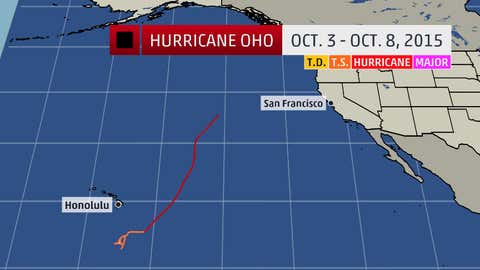
Hurricane Oho Track
Oho formed on Oct. 3,2015,a few hundred miles southeast of Hawaii. The storm slowly intensified while meandering in the same general area and eventually became a hurricane on October 5.
Although not close enough to Hawaii to bring direct effects,Oho did cause increased surf and some flash flooding on the eastern side of the Big Island.
Oho later began to accelerate move northeast,a track direction that is rather uncommon for systems in the central Pacific. The storm also reached 30 degrees North latitude as a hurricane,becoming just one of a handful of systems to achieve such a feat.
A short time after doing so,Oho moved over cooler water and increased wind shear which causing the system to become extra-tropical on Oct. 8,2015.
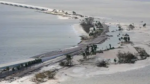
The remnants of Oho produced strong wind gusts over 50 mph and heavy rain across portions of southeastern Alaska and coastal British Columbia on Oct. 9,2015.
Where No Hurricane Has Gone Before?
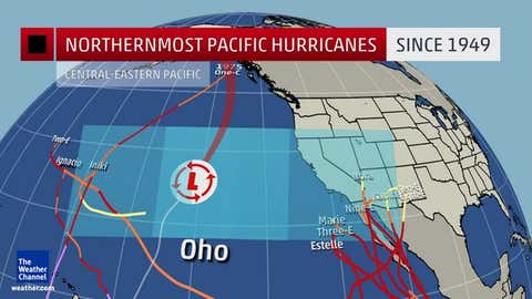
Oho took a peculiar track to the northeast. Although tropical systems do,on occasion,move to the northeast in the central Pacific,since 1949,no late season (October or later) system has formed south of Hawaii and moved to the northeast.

Final Forecast Path
Furthermore,no hurricanes have ventured into the region off Northwest Coast of the U.S.,extending west several hundred miles. However,prior to the advent of weather satellites, a weakening hurricane did strike southern California as a strong tropical storm in 1939.
Ocean temperatures cool rapidly with northward extent in the Pacific,and this is the main mitigating factor when it comes to tropical systems maintaining intensity in the region. However,given the persistent El Nino pattern,such water temperatures have been running anomalously warm this tropical season.
(MORE: A Strong El Nino Is Here to Stay)
Rare Hurricane Track
It's fairly uncommon to see a storm in the central Pacific basin take this type of path,making it an interesting case from a meteorological perspective. On average the central Pacific basin sees far fewer named storms (4-5) in a given season compared to the northwest Pacific (26),lessening the opportunities for this to occur with central Pacific systems.
At times,Alaska,western Canada and the Pacific Northwest can see impacts from the remnants of western Pacific typhoons that recurve into the north Pacific while transitioning into a non-tropical low-pressure system. An extreme example of that happening is the Columbus Day storm of 1962,which contained the remnants of Typhoon Freda.
(MORE: Worst Western Disasters)
Eric Blake from the National Hurricane Center also noticed something peculiar about Oho's track.
In most hurricane seasons,you may see a named storm move westward across 140 degrees West longitude,after which the Central Pacific Hurricane Center takes over issuance of advisories on the system from the National Hurricane Center in Miami.
With Oho,the reverse almost happened. Oho almost moved eastward across the 140-degree longitude line,in which case NHC would have taken over the issuance of advisories. Blake said that has never happened in the modern era.
However,Oho was deemed post-tropical at 141 degrees West longitude,making the point moot. As a non-tropical system,Oho's remnants will now be tracked by the Ocean Prediction Center,another arm of the National Weather Service.
(MORE: Hurricane Central)
Meteorologists Quincy Vagell,Jonathan Erdman and Nick Wiltgen contributed to this article.
MORE ON WEATHER.COM:Retired Hurricane and Tropical Storm Names