Tropical Storm Cindy:Inland Rain and Tornado Maker (RECAP)
June 24,2017
Threats From Ernesto Impacting US Coastal Areas
Cindy was a tropical storm that brought days of heavy rainfall from the Gulf Coast northward into the Ohio and Tennessee valleys.
Cindy developed from a monsoonal low-pressure system near Central America. A heavily sheared tropical low-pressure system moved northward into the Gulf of Mexico and became a tropical storm.
The tropical storm strengthened and expanded as it moved northward. On June 21,winds increased to 60 mph and tropical-storm-force winds expanded to more than 250 miles from the storm's center.
Wind gusts of 45 to 55 mph were clocked along the Alabama,Louisiana and Mississippi coasts June 20-22.
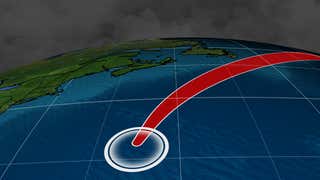
Cindy made landfall as a tropical storm on the northern Gulf Coast between Cameron,Louisiana,and Port Arthur,Texas, early Thursday,June 22 with maximum sustained winds of 40 mph.
Tropical Storm Cindy made landfall early Thursday morning along the Gulf Coast.
In the days following Cindy's landfall,the storm's circulation combined with a cold front dropping south from the Midwest and Plains produced numerous tornadic circulations from Florida to Pennsylvania including one EF1 tornado near Birmingham.
Cindy washed out as a tropical depression in central Kentucky after traveling through Louisiana,Texas,Arkansas and Tennessee mainly as a rainmaker.
Cindy's heavy rainfall brought flooding from Louisiana to Pennsylvania and Ohio. Widespread flooding was reported along the Ohio River on the shores of Kentucky,Ohio and Indiana. The town of Indiana,Pennsylvania recorded more than six inches of rainfall in less than a day,and declared a flash flood emergency.
The highest rainfall amount was 18.74 inches near Ocean Springs,Mississippi. Here are a few select rainfall totals:
Alabama: 8.97 inches near Saraland;8.29 inches in Mobile;4.35 inches near Tuscaloosa
Arkansas: 4.86 inches near DeWitt
Delaware: 1.08 inches near Wilmington
Florida: 10.70 inches in Navarre;9.47 inches near Pensacola;8.14 inches near Panama City Beach
Georgia: 7.15 inches near Stephens;6.85 inches in Starrsville
Indiana: 6.40 inches in Albany
Kentucky: 3.40 inches near Olive Hill
Louisiana: 10.49 inches near New Orleans;6.92 inches in Pearl River;4.63 inches near Baton Rouge
Maryland: 2.78 inches near Accident
Mississippi: 18.74 inches near Ocean Springs;14.40 inches in Gulfport
New Jersey: 3.20 inches near Hopewell
New York: 2.04 inches near Staten Island
Ohio: 4.65 inches near Troy
Pennsylvania: 3.66 inches near Bernville;2.10 inches near Harrisburg;1.37 inches near Philadelphia
Tennessee:1.20 inches near Pulaski
Texas: 5.36 inches in Mahaw Bayou;3.35 inches in Sabine Ranch;2.90 inches near Galveston
Damage from an EF0 tornado occurred in the morning in Fort Walton Beach,Florida. Two additional tornadoes were reported near Biloxi,Mississippi,where there was damage to trees,power lines and fences. Storm spotters reported a tornado just north of Onycha,Alabama,in the evening,but no damage or injuries were reported.
The maximum storm surge most areas saw in the morning was 2 to 4 feet (mainly east of the Mississippi River),with a localized maximum of 6 feet at Shell Beach,Louisiana,according to storm surge scientist Hal Needham.
Flooding from two swollen creeks was observed in Brewton,Alabama,in the afternoon. Some road flooding was also reported in far southern Alabama and the western Florida Panhandle.
Lake Charles,Louisiana,experienced flash flooding in the evening. Knee-deep water was reported on some roads,along with on/off ramps under water. There were also reports of stranded motorists across Lake Charles.
In Alabama,Cindy was blamed for the death of a 10-year-old boy,who was killed by debris June 21 in Fort Morgan. The child,identified June 22 as Nolan McCabe, died of injuries suffered when Cindy's storm surge washed a large log onto the shore and struck him,according to the Associated Press.
Advertisement
June 22
On Thursday morning,coastal flooding was reported in Mobile,Alabama,causing the right lane to be closed on U.S. Route 90 eastbound at Interstate 10. Coastal flooding also occurred in Cameron,Louisiana,in the night between Jun. 21-22 with water across Highway 27.
A wind gust of 62 mph was measured near Cameron,Louisiana,with sustained winds of 48 mph.
Flash flooding resulted in multiple roads closed across western George County in Mississippi.
Storm surge of 4.23 feet occurred early Thursday in Freshwater City,Louisiana,and Lake Charles reported storm surge of 3.24 feet. A storm surge of 4 feet resulted in flooding outside a home near Avery Island,Louisiana.
Early Thursday afternoon,a tornado was observed west of Birmingham,Alabama,with damage in Fairfield consistent with an EF1 tornado.
Structural damage was reported near the Western Hills Mall with at least four injuries.
June 23
Moisture from Cindy combined with a cold front to produce flooding in Indiana,Ohio and Pennsylvania. A flash flood emergency was declared in Indiana,Pennsylvania following more than six inches of rainfall in the valley town in southwestern Pennsylvania.
In Kentucky,an EF1 tornado was also confirmed near Abraham Lincoln Birthplace National Historical Park,where a barn was destroyed.
An EF1 tornado was confirmed near Long Pine,Pennsylvania Friday afternoon,with damage to trees and homes.
June 24
The remnants of Cindy brought strong winds to portions of New Jersey and flash flooding in parts of eastern Pennsylvania. Numerous trees and powerlines were downed in parts of central and southern New Jersey.
MORE ON WEATHER.COM:Atlantic Basin Retired Hurricanes and Tropical Storms
1/96
Hurricane Ian slammed ashore in southwest Florida at Category 4 intensity on Sept. 28,2022. Its peak surge of over 15 feet and wind gusts to 140 mph leveled much of Fort Myers Beach and Sanibel Island. Ian produced record inland flooding in the Florida Peninsula,including near Orlando,that would last for weeks. Ian was the costliest hurricane on record to hit Florida. Ian later made a second landfall in South Carolina,spreading storm surge and high winds from northeast Florida to the Carolinas. (AP Photo/Wilfredo Lee)