Hurricane season's first month often comes with tropical storms and hurricanes that are born close to home.
Some of this early season activity comes from decaying cold fronts and some storms can come with just a day or two's notice.
Dying frontal boundaries are an immediate source of lift and spin,which makes the pathway to becoming a tropical depression or storm a little bit easier.
Cold fronts provide a focal point for bundles of energy to fester on. As cold fronts slide into the Gulf of Mexico or the Atlantic,the bundles assimilate themselves with the tropical airmass and warmer waters that provide a source of moisture and heat. These both act as kicks for the atmosphere to become conducive for tropical storms.

Thunderstorm clusters that come from the Southeast and Plains are another source of potential tropical growth. These clusters,called mesoscale convective systems,often cross through the southern tier of the United States during the early part of hurricane season and lose forward steam as they bubble eastward. An example of this type of formation is Hurricane Arthur,described below.
These systems can have spin of their own,in which they are called mesoscale convective vorticies,and these are particularly likely to become tropical cyclones.
(MORE:10 Hurricane Season Questions Answered)
Both of these systems come with their own moisture and generally have some spin,both of which are boosters for development.
As the complexes reach the ocean,they can use the warmer waters and heat of the sub-tropics to transform into a tropical depression.
A Few Examples
Bonnie,2016
Tropical Storm Bonnie developed from a cold front that dissolved a few hundred miles east of the East Coast. A piece of energy was cut off from that cold front by May 27 and a low pressure system formed in the days following.
Bonnie trekked a few hundred miles back to the North Carolina coast bringing with it gusty conditions and 4 to 10 inches of rainfall in the Carolinas.

Arthur,2014
Hurricane Arthur had a long history of storminess over the South before it became a hurricane in the western Atlantic.
The precursor disturbance,which originated over the southern Plains, swung eastward through the Southeast bringing occasional thunderstorm bursts along the way.
On the East Coast,the disturbance juiced up a dissipating cool front enough to spawn a spin in the far western Atlantic. This spin eventually became Arthur,which intensified into a hurricane as it pivoted northward from the Florida coast toward the Carolinas.

June Climatology
The large majority of tropical depressions and storms that develop in June develop close to home.
Conditions are the ripest in the Gulf of Mexico and in the western Atlantic to start the hurricane season. Waters there are well above 80 degrees,wind shear is beginning to decrease and cold fronts continue to sink southward into these regions to spark storms.

(MORE:When Hurricane Season Typically Ramps Up)
Once systems form,they typically will take one or two tracks. The most common track is to ride cold fronts north and eastward from the Gulf of Mexico across the Southeast and into the Atlantic until the storm reaches cooler waters.
Occasionally storms will form near the Yucatan peninsula or in the western Gulf of Mexico and swing northward toward the western and central Gulf Coast. This was the case with Tropical Storm Allison,which flooded much of southeast Texas and Louisiana coast in the second week of June 2001 and then went on through much of the Southeast.

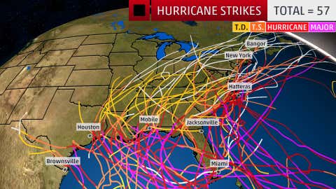
MORE FROM WEATHER.COM:Hurricane Strikes by Month