Hurricane Ingredients

Hurricane development is analogous to having all the right ingredients come together to make the perfect dish for dinner.
Cooks in the kitchen follow recipes with specific ingredients and steps to achieve culinary success. Leave out an important ingredient or miss a key step,and the meal won't be great.
The atmosphere has a lot of variety on its menu. Cooking up a hurricane is the result of following a particular recipe with the following ingredients:
- Warm sea-surface temperatures,usually greater than 80° F.
- Weak vertical wind shear (small changes in wind speed &direction with height) in the surrounding environment.
- Moist and unstable atmosphere.
- Sufficient distance away from the equator (so the earth's rotation can help add some spin to the atmosphere).
Does that sound about right? Did we forget anything?
Go back into the kitchen for a moment. If you have all the right ingredients,mix them all together in just the right amounts,and just let them sit there,the meal won't just cook itself. You have to ignite the burner to start the cooking.
(FORECAST:Tropical Update)
What does this have to do with the atmosphere making hurricanes? Think of this another way.
If you want to leave town fast,what do you do? Choose an interstate with no traffic,make sure there's gas in the car,then drive,right? Wait. There's an important thing in there you do,almost without thinking about it. You have to start the car.
The atmosphere is the same way. Even with all the hurricane-making ingredients on the list above,there will be no hurricane if the burner isn't ignited – or if the car isn't started – to begin with.
Hurricane formation requires an initiating weather disturbance,something with a little spin to spark the beginnings of development. Hurricanes don't just magically appear over the fuel of warm waters where there's no impediment from strong vertical wind shear.
So let's take a look at some of the trouble-making weather disturbances that get the spin going,starting with the most prolific of all Atlantic hurricane-makers:African easterly waves,or tropical waves.
NEXT:Tropical Waves
Tropical Waves

We wouldn't see as many Atlantic hurricanes as we do,if we didn't have the Sahara Desert in western North Africa.
(MORE:Hurricane Central)
During summer there is a persistent temperature contrast between the deep warmth over the Sahara and the cooler atmosphere over the forest and ocean to the south along the Gulf of Guinea Coast.
(INTERACTIVE: Equatorial Africa Satellite)
The result is a mid-level jet stream,strongest at about 10,000 feet,blowing from east to west toward the tropical eastern Atlantic Ocean.
Similar to winds blowing over the ocean creating fairly evenly spaced up-and-down waves in the water,this "African easterly jet"gets a little unstable every few days.

This leads to atmospheric undulations in the north-south sense,or horizontal spin,in the lower levels from the surface up to about 15,000 feet.
A new tropical wave departs western North Africa about every 2-4 days between April and November,with about 60-65 waves per year,on average.
It's these waves that often lead to the formation of the classic "Cape Verde hurricanes",so-named since their development can begin soon after a tropical wave leaves Africa and passes near or over the Cape Verde Islands.
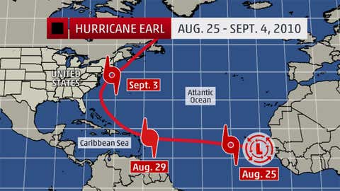
Example:Hurricane Earl
Hurricane Earl from 2010 is an example of a textbook Cape Verde hurricane initiated by a tropical wave.
Earl's parent tropical wave left the west coast of northern Africa on Aug. 23,2010. A surface low formed quickly and a tropical depression was born on the 25th,only a couple hundred miles west-southwest of the Cape Verde Islands.
Earl went on to become a major hurricane near the northeastern Caribbean where it caused extensive damage. It reached Category 4 strength on two separate occasions,narrowly missing a landfall in North Carolina,but causing storm surge flooding there. Earl made a final landfall as a hurricane on Nova Scotia in eastern Canada.
(PHOTOS:Hurricane Earl's damage)
All told,it was 12 days from the initiating tropical wave's departure from Africa and the Canada landfall of Hurricane Earl.
About 85 percent of all Atlantic major hurricanes have their origins traceable to African easterly waves,while about 60 percent of all tropical storms and Category 1-2 hurricanes are spawned by these waves.
Not all tropical waves lead to development soon after they depart Africa. In fact,nearly all eastern Pacific tropical cyclones originate,at least in part,from African easterly waves. Many of these waves traverse the entire Atlantic Ocean and Caribbean Sea without causing development until after crossing Central America.
Since major hurricanes do most of the damage associated with the Atlantic hurricane season,clearly these tropical waves are very important to monitor. But there are other hurricane instigators out there.
NEXT:Dying Cold Fronts
Dying Cold Fronts

Look back in history no further than the weekend of July 16-17,2011 to see that cold fronts that come off the east coast of the United States can lead to the formation of tropical cyclones. In fact,that frontal system accomplished a "two-fer."
Tropical Storms Bret and Cindy both formed from the same frontal system,but at different times.
(WEATHER READY:Power Outage Checklist)
Bret formed first,just off the coast of northern Florida,on July 17 when leftover spin along the dying frontal trough of low pressure moved over the warm waters of the Gulf Stream.


Bret,by the way,is not the only "B"storm in recent history to form from a dying cold front over the western North Atlantic in July.
Tropical Storm Beryl formed off the coast of North Carolina in 2006,then moved up the eastern seaboard and over Nantucket,Mass.,fortunately with no significant impacts.

Tropical Storm Cindy then formed after Bret,on July 20,2011,as a non-tropical low slowly shed its frontal boundaries and developed enough thunderstorms over relatively warm water east of Bermuda.
Granted,neither Bret nor Cindy ever became a hurricane,and neither directly affected land,but the opposite scenario has happened before.
Hurricane Ophelia in 2005,for example,evolved from a tropical depression that formed on Sept. 6 of that year,in part from the trough of a dying cold front that exited the U.S. east coast five days earlier.
(MORE:Hurricane Ophelia 2005)
Ophelia sat and spun just off the coast of the Carolinas as a hurricane,causing an estimated $70 in damage.
NEXT:Upper-Level Troughs and Lows
Upper-Level Troughs and Lows

Tropical waves and fronts directly create low-level spin that can help induce a tropical depression or storm to form,especially when upper-level winds in the area are relatively weak.
Occasionally,though,an upper-level trough or low is directly involved in the process of forming a depression or storm that eventually evolves into a hurricane.
Gustav was a Category 2 hurricane in September 2002 off the northeastern U.S. coast. Gustav had previously passed near the North Carolina Outer Banks as a tropical storm,and ultimately struck eastern Canada at Category 1 strength.
(FORECAST: Tropical Update)
The origins of Gustav included a weak surface trough of low pressure and a potent upper-level low just northeast of the Bahamas. Absent that upper-level low,which enhanced the thunderstorms over the surface feature,the surface cyclone would never have developed.
After it did,the system was first designated a subtropical depression,and it was then a subtropical storm for the next couple of days,due to the direct involvement of the upper-level trough.
By contrast,tropical storms and hurricanes have upper-level high pressure over the low-pressure center at the surface.
Via a complex process,Subtropical Storm Gustav developed more and more thunderstorms near its center and became a tropical storm near North Carolina,then later a hurricane as it accelerated to the northeast off the U.S. coast.

No tropical waves and no frontal boundaries were involved in the original formation,with an upper-level trough instead playing a vital role.
If you think that was a complicated process,wait until you hear how Hurricane Katrina first formed...
NEXT:More Than One Troublemaker At A Time
More Than One Troublemaker At A Time

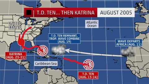
Anyone remember Tropical Depression 10 from 2005? Probably not,but you surely remember the events that followed it,in which that depression played an initial role.
A tropical wave left western Africa on Aug. 8,2005. It led to the formation of Tropical Depression Ten,five days later. Strong wind shear tore that depression apart the next day,on August 14.
A circulation in the middle levels of the atmosphere that was part of that depression met up with another tropical wave that had left Africa on Aug. 11. That interaction resulted in Tropical Depression 12 forming near the Bahamas,later becoming the infamous Hurricane Katrina that struck southern Florida,then the northern Gulf Coast.
(MORE:Hurricane Katrina | The Katrina Diary)

So,got that?
A tropical wave leads to a depression,and that falls apart.
Then,its midsection merges with another tropical wave,and that combination leads to another tropical depression,which evolves into Katrina. I try to stay away from recipes that complicated when I'm cooking in the kitchen.
Here's another atmospheric curve ball. Sometimes,one tropical wave can spawn more than one tropical depression or storm. Again,we look back to 2005.
A tropical wave that departed Africa on July 10,2005 arrived in the eastern Caribbean about a week later,on July 18.
(FORECAST: Tropical Update)
The northern part of that wave led to the formation of a depression on July 21 near the Bahamas,which later became Tropical Storm Franklin,lasting another week beyond then.
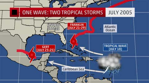
Meanwhile,the southern portion of that same tropical wave went all the way through the Caribbean Sea,eventually leading to short-lived Tropical Storm Gert forming over the southwestern Gulf of Mexico on July 24.
That's one parent tropical wave and two tropical storms as offspring,all blood relatives,with lives spanning an overall period of almost three weeks.
So,as you can see,there are lots of weather features to monitor that could lead to the formation of a hurricane.
MORE ON WEATHER.COM: 20 Amazing Hurricane Images