La Nina Finally Ends:What Does That Mean?
Sign up for the Morning Brief email newsletter to get weekday updates from Weather Now 24 and our meteorologists.
El Niño could develop as soon as this summer,and that could have an impact on the 2023 Atlantic hurricane season.
Over most of the past three years,the back-and-forth sloshing of ocean temperatures near the equator in the central and eastern Pacific Ocean has instead been dominated by La Niña.
But this periodic cooling of those waters has come to an end,with increasing indications that its opposite,El Niño,may be taking hold just in time for the upcoming hurricane season.
This matters because these ocean temperature anomalies can influence weather patterns around the world.
Here is what you need to know about El Niño's typical influence on hurricane season,along with some important caveats.
El Niño usually reduces the number of storms and hurricanes
We examined all hurricane seasons since 1966,when full satellite coverage of the Atlantic Basin began. For each of those seasons,we noted if an El Niño,La Niña,or neither was either in place or developed later in the season,based on data compiled by NOAA.
Admittedly,this doesn't provide a large sample size. There were 21 hurricane seasons with a La Niña,18 with an El Niño and 18 with neither,or what meteorologists call "neutral"conditions.
The average number of storms,hurricanes and Category 3 or stronger hurricanes for each of those is plotted in the graph below,along with the average number in 30 hurricane seasons from 1991 through 2020,for comparison purposes.
Neutral and La Niña seasons were fairly close to the average of 14 storms,seven hurricanes and three Category 3-plus hurricanes. However,the El Niño hurricane seasons have averaged about five fewer storms,two to three fewer hurricanes and one to two fewer Category 3 or stronger hurricanes.

The strength of El Niño also matters
Of those 18 El Niño hurricane seasons,we also examined the seven seasons in which the El Niño was at least moderate intensity,defined by a three-month ocean temperature anomaly of at least 1 degree Celsius above average in that zone of the central and eastern equatorial Pacific Ocean.
Those seven seasons showed a further reduction of one storm,one to two hurricanes and a downward tick in stronger hurricanes from the already reduced El Niño seasons.
When compared to an average season,you can expect almost six fewer storms,four fewer hurricanes and two fewer Category 3 or stronger hurricanes in seasons with a moderate or strong El Niño.

Why does El Niño reduce the number of storms?
The main reason El Niño hampers tropical development is wind shear.
Wind shear either inhibits tropical cyclones from forming,or can put a cap on their intensification. It does that by either blowing thunderstorms away from its center or tilting its cylindrical vortex,disrupting the ideal heat engine that usually allows storms to form and intensify.
Part of the circulation in the atmosphere generated during an El Niño is a belt of stronger than usual westerly winds aloft over the Caribbean Sea. These stronger westerly winds above the typical tropical easterly surface winds lead to increased wind shear.
You can see that increase in westerly winds aloft over the Caribbean Sea in the animation below. In stronger El Niños,wind shear can also be stronger over parts of the eastern Atlantic Ocean,also putting the brakes on development there.

That's important because this long strip of the Atlantic Basin from the western Caribbean Sea to Africa – known as the main development region (MDR) – is a potent hurricane generator.
It's where you'll find almost all disturbances known as tropical waves, one type of seedling from which roughly 85% of all Category 3-plus hurricanes and 60% of all storms develop.
Take away the development potential of this typically fertile MDR,and you can see why one hallmark of an El Niño season is a reduced number of storms.
Wind shear isn't the only negating factor.
At least parts of the tropical Atlantic Basin may also become less conducive for generating thunderstorms during an El Niño,something meteorologists refer to as stability. These are the thunderstorms needed to develop,maintain and grow a tropical system.
Here's what happened during the most recent El Niños
2018
El Niños typically happen every three to five years,according to NOAA.
The most recent El Niño developed in the latter stages of the 2018 hurricane season and lasted into the following spring.
While it didn't develop as soon as expected and was weak,it might have had some influence in fewer storm tracks in the Caribbean Sea in 2018.
2018 had a record seven subtropical storms,accounting for several of the tracks in the central Atlantic in the map below. These helped boost the storm tallies for 2018 (15 storms) but were likely unaffected by the developing El Niño.

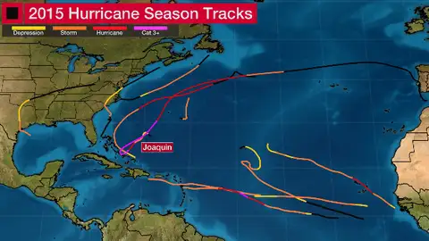
2015
Unlike 2018,an El Niño was both well-established and strong in the 2015 hurricane season. And it definitely left a significant footprint.
Only 11 storms,four of which became hurricanes and two of which strengthened to Category 3 intensity or stronger,happened in 2015,all markedly below the 30-year averages.
Notice the dearth of tracks overall,particularly in the Caribbean Sea,in the map below.
Wind shear near the Caribbean Sea and other parts of the Atlantic Basin contributed to the demise of Hurricane Danny,Tropical Storm Erika,Hurricane Fred,Tropical Storm Grace and Tropical Storm Ida from mid-August through September 2015. Danny was essentially shredded by wind shear near the Windward Islands just three days after it reached Category 3 intensity.
What about landfalls in El Niño seasons?
On average,one to two hurricanes make landfall somewhere in the mainland U.S. each year.
While determining whether a given hurricane will make landfall depends on the steering winds around the storm and the characteristics of that storm at the time,the data we examined also indicates a reduced chance of a mainland U.S. hurricane landfall in El Niño seasons – especially in stronger El Niño seasons.
In some sense,this is a reflection of fewer hurricanes during El Niño. Fewer darts mean fewer chances to hit the bull's-eye.

Damaging storms can occur in every season,even during El Niños
While the chances of hurricane landfalls in the U.S. diminish during El Niños,that doesn't mean the U.S. is off the hook.
Hurricane Florence flooded parts of the Carolinas and Hurricane Michael dealt a devastating Category 5 strike on Florida's Panhandle despite the late-developing,weak El Niño five years ago.
Among 2015's reduced hurricane tally,Joaquin still hammered the Bahamas during an agonizingly slow track.
And it doesn't take a hurricane to be impactful,especially regarding rainfall flooding.
Tropical Storm Erika was ripped apart by wind shear and dry air near the Dominican Republic during the strong El Niño of 2015. But before that happened,it triggered deadly and destructive flooding in Dominica.
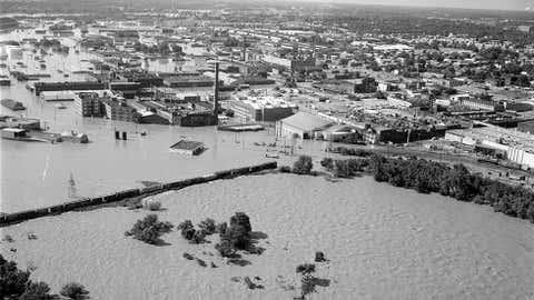
During 1972's stronger El Niño,what was once Hurricane Agnes curled back toward the Northeast U.S. as a tropical storm. The massive,deadly flooding that resulted was America's costliest weather disaster at the time.
It only takes one
There are still some uncertainties with El Niño,including if it develops,how fast it develops,and how strong it becomes,that will have at least some impact on the hurricane season ahead.
However,keep in mind that El Niño is just one influence on how active a hurricane season will be.
The distribution of warmer and cooler Atlantic Ocean water and dry air are just a few other factors that can determine how many storms and hurricanes form.
Despite what could be the first El Niño during hurricane season in five years,prepare for this season as you would any other. Assume this could be the year a hurricane threatens your area,and develop or refresh your hurricane plan before a storm approaches.
It's cliché but true – it only takes one hurricane strike in your area to make it an active season,regardless of El Niño.
The Weather Now 24’s primary journalistic mission is to report on breaking weather news,the environment and the importance of science to our lives. This story does not necessarily represent the position of our parent company,IBM.