Don't Underestimate The Power Of Water
Historic flooding is swamping parts of Nebraska,western Iowa and southeast South Dakota,shattering records in at least six locations,so far.
Some flood protection systems have been compromised,bridges washed out and evacuations ordered in a number of locations in central and eastern Nebraska. Evacuations have also been ordered just across the border in western Iowa.
(LATEST NEWS:Evacuations Ordered,Dams Compromised)
Flooding is widespread in the city of Yankton,South Dakota,and has prompted road closures in western Iowa,including some interstates north of Omaha and Council Bluffs.
It took a perfect storm of meteorological factors to produce this terrible flood event.
Persistent Cold
First,the ground was frozen solid from cold that had been persistent,for the most part,since Groundhog Day.
It was the eighth coldest February on record in Nebraska dating to 1895,and third coldest in South Dakota,according to NOAA's National Centers for Environmental Information.
That was followed by one of the coldest March outbreaks in years,sending temperatures crashing below zero.

This persistent cold developed a thick ice cover on area rivers.
Then there was the snowpack.
It was a record snowy February in Omaha,Nebraska. While the snow depth wasn't terribly impressive,generally from 5 to 13 inches,the persistent cold held it in place in eastern Nebraska,western Iowa and southeast South Dakota.
Rapid Snowmelt
Whether melting snow can trigger flooding itself depends largely on how fast that melt happens.
And that rate of melt depends on how quickly it warms up.
In this case,Omaha ended their longest March streak below freezing on March 9,kicking off a number of days with highs above freezing.
Warm air streaming ahead of the Bomb Cyclone,Winter Storm Ulmer,only accelerated the snowmelt.
By the time Ulmer's fury arrived,most snow cover in this part of the Missouri Valley was largely gone. Consider these snow melt rates from March 8 through March 13:
-Omaha,Nebraska:7 inches melted
-Sioux City,Iowa:11 inches melted
-Valentine,Nebraska:11 inches melted

More important for flood forecasting,though,was the water contained in the snowpack.
On March 9,before the most significant snowmelt began,NOAA estimated parts of eastern Nebraska,western Iowa and southeast South Dakota had at least an inch,if not a few inches,of water contained in the snowpack.
Incidentally,one other example of how rapid snow can melt came from just south of Green Bay,Wisconsin,March 13-14,triggering flooding there.
Ulmer:The Breaking Point
We mentioned earlier that warm air spread north ahead of Winter Storm Ulmer. Highs on March 12 were into the 40s and 50s in parts of Nebraska and South Dakota. Those highs shot up into the 50s and 60s across much of the region the following day.
Ice jams formed on some rivers in response to this warmth.
But soaking rain from Ulmer was the real back-breaker that tipped this flood event into record territory.
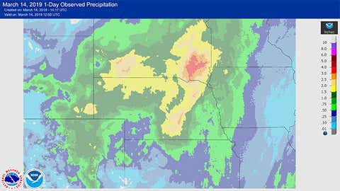
Yankton,South Dakota,picked up a whopping 2.89 inches of precipitation,almost entirely rain,in 24 hours ending 7 a.m. CDT March 14. That's over an inch above their average precipitation for the entire month of March,setting an all-time March 24-hour precipitation record that would also have topped the current record for April.
Norfolk,Nebraska,which had to partially evacuate due to flooding,picked up 1.66 inches in that same timeframe.
This heavy rain either accelerated residual melting of leftover snowpack,or simply ran off the rock-hard frozen and saturated ground.
The sudden influx of water stressed water protection measures,washed out bridges,broke ice jams that unleashed downstream flood waves that produced the surreal sight of large chunks of river ice on flooded roads.
Unfortunately,the threat of major flooding is also in play in other parts of the Midwest this spring due to some of these same factors,with late spring snow,rain and sharp warm spells the big wild cards.